

 Snow, ice and a hazardous wintry mix are all likely
Just days after freezing rain triggered a deadly 100-vehicle pileup in Fort Worth, parts of Texas and the South are preparing for what could be a dangerous and sprawling winter storm by early next week.
Significant accumulations of snow, ice and rain are likely, with wintry precipitation potentially reaching as far south as the northern Houston suburbs. There’s even the possibility of severe weather in parts of the Southeast as the storm moves toward the East Coast.
Bone-chilling cold and a barrage of winter storms: Behind this crazy U.S. weather pattern
Accompanying the storm will be a shot of bitter Arctic air spilling all the way to the Gulf Coast, with temperatures up to 40 degrees below average for this time of year.
Winter storm watches are in effect across much of eastern New Mexico, Texas and Oklahoma, as well as the northwestern corner of Arkansas. Oklahoma governor Kevin Stitt (R) declared a winter weather emergency for the state’s 77 counties.
The storm is a few days away from fully forming, but already the ingredients were beginning to come together early Friday. A pair of upper-level disturbances, the first one diving southeastward over California and the second located between the Aleutians and the West Coast, will generate a potent system at the surface.
The leading piece of high-altitude energy will intensify as it dives from California into Mexico before pivoting east and emerging over the gulf over the weekend. Counterclockwise winds blowing around that system will induce a northerly breeze over most of Texas and the southern Plains, drawing cold air south and providing the conditions needed for a snow or ice storm.
Energy from that low will then be absorbed by the second upper-air system approaching from the northwest, which will slide through the four corners region and pass over West Texas. Simultaneously, it will invigorate a developing surface system Sunday into Monday.
Precipitation will break out in the Oklahoma and Texas panhandles, as well as New Mexico on Sunday, falling as snow with cold air in place. Snowfall rates up to an inch per hour are possible in the high elevations of eastern New Mexico. Lubbock, Amarillo and Midland will all see snow by Sunday evening.
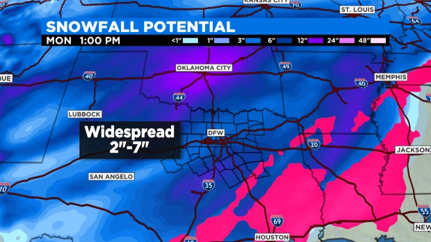
Overnight into early Monday, snow could make it to places like San Angelo, Abilene and Wichita Falls, and stretch up the H.E. Bailey Turnpike into Oklahoma City. Dallas could get into moderate snow by Monday morning, too, and there’s a chance a few flakes could fly as far south as Austin.
It’s possible the heaviest snowfall skirts the Sooner State to the south, but at least light snow will fall there most of Monday.
Thereafter, accumulating snow looks to move up the Mississippi Valley, piling up in extreme northwestern Louisiana, Arkansas, northwestern Tennessee and perhaps into Kentucky, the Ohio Valley and Appalachians. This may be a rare, significant snowfall event for these locations.
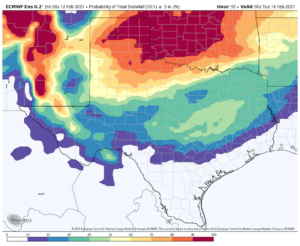
All told, a broad three to five inches are likely in most of central and west Texas, with five to eight inches in the Panhandle and a few spots approaching double digits.
In central and western Oklahoma and southern Kansas, six to 10 inches, with a few one-foot totals, are expected. Temperatures in Oklahoma City could fall to zero degrees Sunday night, and the frigid air may allow for fluffier snow.
The Dallas-Fort Worth Metroplex could be looking at a three-to-five-inch snowfall, with about the same in Tulsa, and perhaps a slushy inch or two in Little Rock. Such amounts would be enough to bring travel to a standstill in Dallas and Little Rock, in particular.
Snow and ice in the Mississippi Valley
There’s also the likelihood that a lot of ice could fall in the transition zone, where milder air at the mid-levels overspreads a shallow dome of frigid air hugging the ground. That would allow moisture to fall as liquid, but it would immediately freeze on contact with any surface.
The overall weather pattern favors a strip of icing, with potentially significant effects, running parallel to the stalled cold frontal boundary that will be draped from the Gulf of Mexico to the Appalachians. While it’s too early to know any of the specifics, there’s an elevated risk of icing next week in places such as East Texas, Louisiana, Mississippi, Alabama and Tennessee.
The weather pattern, with dense, cold air locked in place at the surface, offers an ideal setup for producing ice storms. Such events can snarl travel, cause trees to topple and knock out power for days across broad areas.
There’s a slight chance that a thin glaze could even make it into the northwestern suburbs of Houston, where temperatures Monday will sit in the mid 20s and could fall into the mid teens Monday night. A winter storm watch is in effect for Houston and Galveston.
The National Weather Service is forecasting a low of 13 degrees Monday night at Houston’s Intercontinental Airport, which would be the lowest temperature observed there since 1989.
A wintry mix is even possible closer to the border with Mexico.
“All combinations of [weather] are expected … starting out as a rain-freezing rain-sleet event transitioning to a sleet-snow mix across some inland portions as it exits the area,” wrote the Weather Service in Galveston in regard to the Sunday night and Monday event.
Thereafter, there are even signals that additional winter weather could develop later next week. It’s an exceptionally active winter weather pattern that looks to continue to cause problems for the forecastable future.
Source: https://www.washingtonpost.com/weather/2021/02/12/texas-snow-ice-mississippi-valley/
0 Comments